


Fetching data
{{ areaName }}
{{ (tickerData.subareas[subarea][activeTickerMonthIndex].p) ? "£" + commaSeparateNumber(Math.round(tickerData.subareas[subarea][activeTickerMonthIndex].p)) : "N/A" }}
{{ ((tickerData.subareas[subarea][activeTickerMonthIndex].pD - 1) * 100).toFixed(1) + "%" }}
N/A
Sort Data
Baseline
Month
The components of our ticker

This refers to the designated area identified as region, borough or postcode.

The dotted line represents the average PPSF of the area. A single dot above or below the dotted line denotes if the area is more expensive or less expensive then the average of all the areas displayed on the ticker.
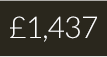
This is the average price per square foot of real estate in this area as of the most recent monthly data available.
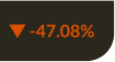
Represents the annual price change in this area.
The number of sale transactions completed for the area in the defined month.
The change in number of sale transactions completed from the same period last year.
The ontology of a post code


Feedback & Get in touch
Contains HM Land Registry data © Crown copyright and database right 2021. This data is licensed under the Open Government Licence v3.0.
Ticker version: 2.02
Data as of: {{ months[new Date(tickerMonths[0].slice(0, 4), tickerMonths[0].slice(5) - 1).getMonth()] + " " + new Date(tickerMonths[0].slice(0, 4), tickerMonths[0].slice(5) - 1).getFullYear() }}
Powered by ![]() Brydg
Brydg